Who doesn't like a good storm? For some, tracking the weather is more than a passing fancy. For people like Barrie's Adam Skinner, who is the driving force behind Instant Weather Ontario, a wild weather day like Thursday is what he lives for. Here's a behind-the-scenes look at what it's like in the eye of the storm.
Anticipation was clearly building. A severe weather watch had been issued in various parts of the province. Maps with arrows and circles started appearing with more frequency on Twitter as the afternoon progressed on Thursday.
Instant Weather Ontario posted an “extreme severe risk” in the southernmost portions of Ontario as its principal, Adam Skinner, prepared for another significant weather livestream on social media.
But the chatter had already begun on its YouTube channel. Ontario's Most Haunted anticipates “a very eventful weather afternoon”. Others report in from Wallaceburg, Alexandria, Dorchester, London, Wainfleet, Utopia and Wasaga Beach with either sightings or predictions on what is about to occur or just to say hi.
“Things are already kicking up” with activity in the Niagara region and storms in Muskoka, including a rotation near Mactier heading to Huntsville with a view to more activity in Severn, Skinner begins.
 Then the chat window kicks into a continuous roll as watchers want to know what they can anticipate in their corner of the world.
It’s 3 p.m. on Thursday and more than 700 people are logged in to watch the pronouncements and climbs past 1,200 within minutes. Then, with 1,700-plus viewers on YouTube and a subscriber base of 11,400, Skinner reports more than 4,800 are watching through all the social media channels combined as colleague Brennen announces from off screen that Flint, Mich. is being hit with large hail (later reported to be 2.5-inches in diameter) with the system moving northeast.
Skinner settles in, likely right into the evening. It’s a pure livestream, no filters. If Skinner needs nutrition, out come nuts, along with some cheese and crackers for this mid-to-late July livestream.
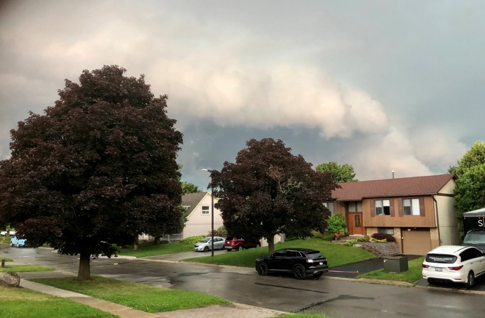
If he were to climb out of the basement of his Barrie house where he’s broadcasting early on in this session, he’d see sunshine and a mostly clear sky with a brisk breeze. But he knows that will soon change.
The buzz of the day, of course, is the possibility of twisters, on the heels of the damaging double EF1 tornadoes that tore through Barrhaven, west of Ottawa, ripping up 125 homes just a week earlier. Weather watchers of all types tune in, many of them reporting severe weather, known as ground truths.
But there are others. One wants to know if he should cancel baseball practice, another announces she’s more than skittish about bad weather.
“Wooaa, this is crazy strong. Sarnia needs to take shelter immediately,” Skinner announces at 4 p.m, adding there’s a 12 per cent chance of a tornado there. He quickly types out a warning to subscribers. “That looks super nasty.”
A minute later Brennen reports that there’s a tornado warning for Sarnia. And the wind there keeps picking up, reaching up to 126.5 km/hr.
Soon a submitted video pops on the screen showing a green sky and a nasty-looking formation in Sarnia with more images from Chatham-Kent. At 4:24 p.m. extensive damage is reported in Sarnia.
***
Skinner, a former musician, has been doing severe weather livestream broadcasting for a decade, supported by a “community” of volunteers. As a company they’ve developed a free Instant Weather app and a pro version just went through extensive beta testing.
There’s a staff now of seven, most part-time and as needed. There are also volunteers. Skinner, however, works it full time.
He first got his feet wet in meteorology chasing the weather. He describes, with great detail, how he ended up almost atop a 2013 event northwest of Shelburne.
“The storms were actually moving forward… as fast as a freight train… by the time we went in it was wrapped around us,” Skinner explained in an interview well ahead of Thursday’s livestream.
A car had been pushed off the road, a building exploded, a horse stable fell, sheet metal few through the air - all as if in slow motion.
It was an EF1 tornado, unseen through the rain.
That, he explained, was the end of the chase for him, and the catalyst to move into watching, with the help of Facebook.
***
“Windsor is getting hammered right now,” comes Skinner’s 4:41 p.m. report as a warning appears on the screen: “Take shelter Warwick & Chatham-Kent now!!!!!”
The chat screen rolls quickly as observers report trees down in Sarnia and elsewhere. A severe thunderstorm warning is then issued for Barrie.
More than 8,000 people are now tuned in to Skinner’s livestream 90 minutes in. He updates it to 9,000 less than 10 minutes later, closing in on the record 11,000 viewers they had a couple years back. And sure enough, by 5:40 p.m. 11,173 people are online.
As he watches Skinner becomes concerned, tracks his wife’s location on her phone and then calls her.
“Can you come home now please,” he asks, with some insistence before this live audience. “There’s a rotation close to Collingwood.”
***
Skinner performed with Atlantis Blueprint, opening for the larger bands coming through the Barrie area while also teaching music. One of his students was the son of severe weather scientist David Sills. Sills then moved from Barrie to London to become executive director of the Northern Tornadoes Project (NTP) at Western University which aims to better detect tornado occurrence in Canada and improve severe weather prediction.
When severe weather began consuming more of Skinner’s time, some natural collaborations followed.
Skinner, and a “community” of watchers, were frustrated with lagging warnings of weather events and set out to create their own alerts and eventually Instant Weather was born.
“The NTP relationship with Instant Weather began because they have so many subscribers that report severe weather – so it became a key source of severe weather reports for us,” wrote Sills in an email Thursday, in between his own tweets about the severe weather as it unfolded all around him.
“But we also entered into a collaboration on a radar processor and viewer. That is now available publicly by subscription (IW Pro Radar Suite). Because of the development of the radar suite, Adam is also involved in the Northern Hail Project that is currently based in hail alley in Alberta (between Edmonton and Calgary).”
***
At 4:50 p.m. the radio broadcasts a tornado warning for southwestern Ontario, along with the thunderstorm warning for Barrie. Seven minutes later comes that inevitable tornado warning for Barrie - which has a history with tornadoes — and Collingwood.
BARRIE: SEEK SHELTER!
— Instant Weather Ontario (@IWeatherON) July 20, 2023
(Locations listed below description)
The Barrie area needs to seek shelter NOW! Focused rotation with a tornado likely.
If you are in the path, get to the lowest level (preferably a basement) of a sturdy structure and get to the most interior room that… pic.twitter.com/i5YSzgJ7wb
“But Barrie isn’t a problem at the moment, the problem is Collingwood,” Skinner says.
Sure enough, the system soon appears to be heading to Barrie and rain starts falling in the north end. The phone buzzes with alerts and pop-ups appear on computer screens. And at 5:35 p.m. Skinner declares that Barrie is becoming a problem.
“Dorchester needs to take shelter,” Skinner announces at 5:27 p.m. as he watches a continuing rotation. “There’s just stuff all over the place.”
He then disappears to check in with his family and Brennen takes over.
“If there is a tornado, it is likely rain-wrapped,” Brennen explains as the wind in north-end Barrie whips up. “Barrie, take shelter,” he warns.
Then the skies open up, it pours, there’s some lightning and this appears in the chat: “TORNADO IS FORMING SOUTHEND BARRIE.”
The storm then heads northeast to Washago, Orillia and then Bala.
At 6:47 p.m. Skinner responds to a query: “Barrie’s good.” And then comes a report that a funnel cloud was spotted in Bradford.
It was a frenetic day for those who follow the weather.


